GEOGRAPHIC PROFILE
|
|
Geographic Location, Land Area and Accessibility
Municipality of Mabinay, once a part of the municipality of Bais, became a town on June 25, 1959 by virtue of R.A. 2496 which was signed by President Carlos P. Garcia and took effect on January 1, 1960 under the sponsorship of Congressman Lorenzo L. Teves. Upon its creation, its mother municipality ceded to Mabinay some of her big thirteen (13) barangays, namely: Bagtic, Baliw, Lamdas, Himocdongon, Bato, Luyang, Namangka, Tadlong, Lumbangan, Paniabonan, Inapoy, Barras and Banban.
On June 18, 1966, under R.A. 4818, Mabinay’s territory was expanded to cover 12 more barangays. Four from municipality of Manjuyod: Pandanon, Dahile, Samac and Namangka; and eight from municipality of Bais: Tara, Campanun-an, Pantao, Cansal-ing, Dagbasan, Bagtic, Mayaposi and Mabaja.
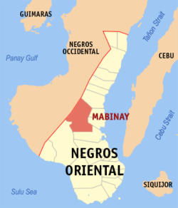
The Municipality of Mabinay is situated in the central part of Negros Island that is bounded by the Municipality of Ayungon in the North, the City of Bais in the south, the Municipalities of Bindoy, Manjuyod and portion of Bais City in the East, and the province of Negros Occidental in the West. It is about 87 Kilometres Northwest of Dumaguete City, the provincial capital of Negros Oriental and about 108 Kilometres from Bacolod City, the provincial capital of Negros occidental.
The province of Negros Oriental, of which Municipality of Mabinay is a component municipality, is the other half of Negros Island. The province forms a narrow strip extending two-thirds of the way, which measures approximately 165 kilometers from north to south and from east to west is about 78 kilometers at its widest and 13 kilometers at its narrowest. It is bounded by a series of rugged mountains from its sister province of Negros Occidental and separated from Cebu province by Tañon Strait.
Mabinay is situated practically in the central part of Negros Island abutting the western side of the provincial boundary. The municipality of Ayungon bound it in the north, the City of Bais in the south, the municipalities of Bindoy and Manjuyod and portion of Bais City in the east, and the province of Negros Occidental in the west. It is about 87 kilometers northwest of the provincial capital - Dumaguete City and can be reached from the city via the circuitous but well-paved national road that cuts across the middle of the province from Bais City to Negros Occidental.
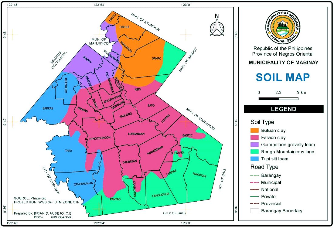
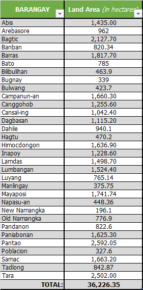
A land-lock municipality, Mabinay, which claims a total land area of 36,226.35 hectares or 6.7% of the total land area of the province, lies along 122°48’ and 123°03” east longitude and 9°35’ and 9°50’ north latitude. It is composed of 32 barangays.
On June 18, 1966, under R.A. 4818, Mabinay’s territory was expanded to cover 12 more barangays. Four from municipality of Manjuyod: Pandanon, Dahile, Samac and Namangka; and eight from municipality of Bais: Tara, Campanun-an, Pantao, Cansal-ing, Dagbasan, Bagtic, Mayaposi and Mabaja.
The Municipality of Mabinay is situated in the central part of Negros Island that is bounded by the Municipality of Ayungon in the North, the City of Bais in the south, the Municipalities of Bindoy, Manjuyod and portion of Bais City in the East, and the province of Negros Occidental in the West. It is about 87 Kilometres Northwest of Dumaguete City, the provincial capital of Negros Oriental and about 108 Kilometres from Bacolod City, the provincial capital of Negros occidental.
The province of Negros Oriental, of which Municipality of Mabinay is a component municipality, is the other half of Negros Island. The province forms a narrow strip extending two-thirds of the way, which measures approximately 165 kilometers from north to south and from east to west is about 78 kilometers at its widest and 13 kilometers at its narrowest. It is bounded by a series of rugged mountains from its sister province of Negros Occidental and separated from Cebu province by Tañon Strait.
Mabinay is situated practically in the central part of Negros Island abutting the western side of the provincial boundary. The municipality of Ayungon bound it in the north, the City of Bais in the south, the municipalities of Bindoy and Manjuyod and portion of Bais City in the east, and the province of Negros Occidental in the west. It is about 87 kilometers northwest of the provincial capital - Dumaguete City and can be reached from the city via the circuitous but well-paved national road that cuts across the middle of the province from Bais City to Negros Occidental.
A land-lock municipality, Mabinay, which claims a total land area of 36,226.35 hectares or 6.7% of the total land area of the province, lies along 122°48’ and 123°03” east longitude and 9°35’ and 9°50’ north latitude. It is composed of 32 barangays.
BARANGAY SUBDIVISION |
HOUSEHOLD DISTRIBUTION |
|
|
